 |
Vale Crucis, Afon Eglwyseg, Dinas Brân LLANGOLLEN CIRCULAR Saturday, 14th July 2018 |
|
| Our Walk Canal Vale Crucis Eglwyseg Offa's Dyke Dinas Brân Llangollen Maps Evening Read Me |
Our Walk
The weather was quite warm today, so a "shortish" 10 to 11-mile walk, espousing the lower ground and for a good part of the way traversing wooded countryside, seemed a good ploy. This was appreciated by participants. We started along the Llangollen Canal, turning off near the Motor Museum to reach the Abbey of Vale Crucis which was interesting to visit. We then reached the wooded Clwydian Way and subsequently Avon Eglwyseg. We eventually came on to the more exposed Offa's Dyke path, from which we reached Castell Dinas Brân, which towers over Llangollen, and at 320 m, was the highest point on our walk. For his sins, Eric was the nominal walk leader!
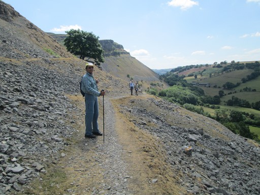
Here we are on Offa's Dyke path, the scree on either side.
We set off via the Llangollen Canal
Before we set off on our respective walks and activities, we thought that a group picture in front of our hostel might be nice. Because, as we know, a group of Cloggies being photographed is a dynamic entity, I have produced three separate pictures. After the group photographs, those of us on our circular walk then went past the railway station to the Llangollen Canal. From here we reached Vale Crucis and the Clwydian Way.

So here we are. Well, most of us.

Here's our second group picture with
"someone" trying to make a quick escape from being immortalized in pixels.

Third picture for luck!
I do believe one of us is trying to do a lumber-jack dance.

On our way out of town we pass Llangollen Station, present terminus of the Heritage Railway.

A DMU is standing at the far platform.

We "climb up" to the Llangollen Canal. This looks like a horse-drawn boat.

Here is the "boat park" on the most westerly navigable part of the Llangollen Canal.
The canal on the left, with the "No Entry" sign, leads to the Horseshoe Falls,
where some of the waters from the Dee are channelled into the canal.

There aren't any boats here ("No Entry" you know), but it's a pretty canal scene.
Soon we shall leave the canal and turn north to Valle Crucis and the Clwydian Way.
Vale Crucis
Vale Crucis means the "Valley of the Cross". The Abbey was established in 1201 by Cistercian monks. As you can guess, Henry VIII destroyed the Abbey (actually 336 years later), and to really screw up the rural ambience right regally, a new-age caravan site was established next door. However, enough was left of the abbey to allow us to see the chapter house and the dormitory and the remains of the church, the cloister and the refectory. A nice dip into British history on our walk.

Here are two views ...

... of the church.

This cool passageway leads to ...

... the Chapter House where monks met and listened to daily readings.
Here they could also confess their sins - if they had any to confess.

In the dormitory above, some slabs from old gravestones have been lined up ...

... and there is also this interesting old (very old) fireplace lintel.

It's sunny outside ...

... and we get some more views of the main church ...

... with the stumps or bases of the columns that must have supported an impressive roof.
Probably a lot of the stone work was pinched after the demolition
and incorporated into local houses.

The church had a nice main Norman entrance.

Here's a final view before we continue on our walk.
Afon Eglwyseg
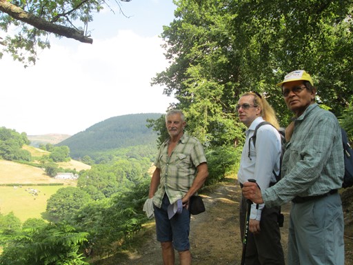
Afon, or River, Eglwyseg marks roughly the northern edge of our walk. At one point we can look into the valley leading to Pentre-dwfr. It's July, and the landscape has donned its lush green summer mantle. We eventually change our direction and head towards the east and the Offa's Dyke Path. Before we reach this path, we realize that it's time for lunch, and what better place than overlooking the verdant valley of Afon Eglwyseg!

Here we look towards Pentre-dwfr ...

... and enjoy the summer countryside.
Here we are again at the same spot.

We turn towards the east ...

... and the foothills of Eglwyseg Mountain.

We shall shortly be reaching the Offa's Dyke Path ...

... but not before we have had our "lunch with a view"
Offa's Dyke Path
Offa was an Anglo-Saxon king of Mercia from AD 757 to 796. He is believed to have ordered the building of Offa's Dyke, which follows roughly the present border between England and Wales, and at 177 miles in length, is Britain's longest ancient monument. Offa's Dyke Path, as might be expected, follows Offa's Dyke.
Our path takes us through the scree ...

... which gradually assumes a cloak of lush green summer vegetation.

Eventually, after Bryn Goleu, the path widens into a track ...

... and we have Castell Dinas Brân in our sights.
Castell Dinas Brân - Castle City of King Brân
King Brân was the legendary first king of Britain and according to Celtic mythology was a giant. He happened to live at Castell Dinas Brân, 320 m above sea level. Brân is the welsh for crow and raven (no distinction), so crows are associated with King Brân and his "Castell". The present castle probably dates to the 1260s, and its ruins tell of a lively (and perhaps not always so lovely) past. Edward I of England came to power in 1272 and the "Castell" played its part in the subsequent wars between the Welsh and the English in 1276.

Before we ascend to the Castle we are greeted by this crow.

On top we have a nice view towards the east of the Pont Cysyllte aqueduct.

As we catch our breath there's time to admire the view towards Llangollen in the Dee valley.

There's still a little way to go, but we are nearly at the top.

As we stroll around the old walls ...

... and through the old arches, we wonder what sort of life the mediaeval occupants of this Castell must have had. Usually lively but probably not always lovely.

Here we look down to Llangollen.

Here we look along the Dee valley towards the west.

Here we look "northish" towards Afon Eglwyseg and the landscape we traversed earlier in the day.

We take a last look at the Castell ...

... before we head down to Llangollen.

On our descent we meet this wooden crow which looks rather sad and bedraggled.

This crow, on the other hand,
proudly guards our way down from (or second way up to) the Castell.
Return to Llangollen
From the Castell, we descend to the Llangollen Canal and hence back to our hostel. On the way we pass Llangollen Station, where I found that steam trains were operating again today, the overnight rain having satisfactorily diminished the fire risk. I managed to get some pictures.

Along the canal we past once more the house with crenellations. The house seems to be built in an architectural style popular at the beginning of the 19th century.

The width of the canal at this point makes us appreciate the designation "narrow boat".

Here's a high capacity narrow boat - waiting for more tourists tomorrow.
The writing suggests that it plies between Llangollen and the Pont Cysyllte and Chirk Aqueducts.

Yes, steam is running today on the Llangollen Railway.

Here is Large Prairie, number 5199, running around its train.
Copper chimneys, brass safety valves and brass number plates
were attractive features of GWR locomotives.

Number 5199 belongs to Collett's 5101 class, introduced in 1929.
This instantiation of the said class was delivered in 1934 - before my time!

Here's 5199 again. Shame about the black livery.
The original GWR Brunswick Green would have looked much more attractive
- especially to younger visitors brought up on the exploits of "Thomas the Tank Engine"!

Here we are, back at the hostel.
The outside light has come on a tad early.
I mean, we are all still to enjoy our respective evening repasts.

A quick look at the fridge magnet in the hostel's kitchen reminds us that the Llangollen Railway has "more or less" reached its new terminus, ten miles out of town to the west.
Our Evening
Some of us had an early meal at the "Corn Mill". Others had a much later meal at the "Cottage Tearooms & Bistro" in the main street of Llangollen. Yet others visited establishments dotted around the town. Below you see, for interest's sake, an old print and a Victorian photograph, both of which I photographed at the "Corn Mill".

Here, looking north eastwards, are Llangollen's 16th century bridge and beyond, Castell Dinas Brân. The print is not dated, but probably is from the late 18th or early 19th century.

Here is a Victorian photograph, looking towards the west, of Llangollen Bridge and the "Royal Hotel". The picture's description reads, "Llangollen Bridge and Weir circa 1880".
Eric Scharf
Version: 2018-09-19 @19:18
SAGAX REX HANC RETIS ORBIS PAGINAM PINXIT ANNO MMXVIII.
© Eric Scharf 2018